SE CASC Researchers Simulate Climate Changes in Puerto Rico & U.S. Virgin Islands

A new SE CASC-supported publication, High-resolution dynamically downscaled rainfall and temperature projections for ecological life zones within Puerto Rico and for the US Virgin Islands, was published on August 23 in the International Journal of Climatology. The following post was written by SE CASC Science Communications Specialist, Ashlyn Shore.
Tropical islands are especially susceptible to extreme weather events because of their location and their size, factors that also make it particularly challenging to simulate how tropical island climates may change in the future. As part of a SECASC-funded project, climate scientists have recently developed high-resolution dynamically downscaled climate change projections for Puerto Rico and the U.S. Virgin Islands (USVI) centered on the mid-century (2050). These climate model simulations were used to explore what kind of changes in temperature and precipitation are in store for important ecological regions in the U.S. Caribbean. While these tropical islands will respond to the global changes in climate due to rising greenhouse gases, locally the most important changes will be driven by the island microclimates – which can only be captured by high-resolution climate models like those used in this study. The simulations indicate large increases in days with extreme heat and reductions in mean annual rainfall.
Islands in the Caribbean are vulnerable to extreme weather-related disasters. In 2015, Puerto Rico experienced one of the most severe droughts on record and just three years later was struck by Hurricane Maria in which rainfall exceeded 30 inches in some areas. These extreme temperature and precipitation patterns are only expected to become more intense under the conditions of a changing climate. In addition, the terrain of both Puerto Rico and USVI contributes to sharp temperature and precipitation gradients over short distances (<10 km) within the islands.
Global Climate Models (GCMs) use mathematical representations of Earth’s climate system components to simulate long-term changes within the climate system in response to possible changes in Earth’s energy balance as greenhouse gas emissions increase. However, the GCMs are unable to resolve some of the important climate drivers within the landscape, such as complex terrain and local land use/land cover, that help to create the rich mosaic of habitats at regional to local scales in the Caribbean islands. Simulating the response to these landscape scale features is ideal for these smaller tropical islands – a process that utilizes regional climate models to simulate plausible changes in the climate at more localized scales (2-km in this study).

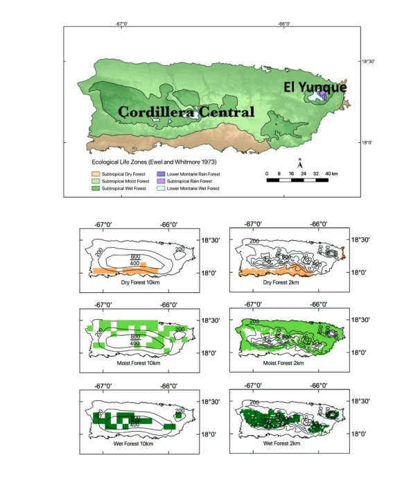
This study builds on prior research, providing downscaled temperature and precipitation projections for the three largest life zones within Puerto Rico and the USVI under a severe climate change scenario (RCP8.5) using a historical time slice (1986-2005) and future time slice (2041-2060). Evaluations were performed for the subtropical dry forest, subtropical moist forest, and subtropical wet forest zones, land areas defined by their mean annual biotemperature, mean annual precipitation, and annual potential evapotranspiration ratio. This analysis includes quantifying changes to the mean and extremes within these life zones in Puerto Rico, including the diurnal cycle and tails of the distributions where large uncertainties and little information exist regarding climate change.
Lead author of the publication, Jared Bowden explains that “stakeholder-driven research was an important component in this project. Prior meetings with stakeholders helped to determine the climate model fields to archive and model resolution needed to simulate the complex island climate. The stakeholders also gave us insight into the types of analysis needed within the islands, such as those working with species conservation and water resources, and the analysis in this study is in response to those needs.”
In this study, two regional climate modeling systems were used to downscale two select GCMs. These select GCMs are part of a large international coordinated climate modeling project known as CMIP5, designed to better understand global climate change and consisting of more than 30 different GCMs. Using multiple GCMs and regional climate models helps to scope plausible changes in the climate at local scales, but to downscale using regional climate models is computationally expensive and so is necessarily limited to a select few GCMs.
Substantial increases in temperature and decreases in precipitation are expected for all life zones within Puerto Rico by 2050. All simulations project more than 50 days of unprecedented heat for all life zones for both maximum and minimum temperatures – that is, future days that exceed the largest historical baseline simulated temperatures. More specifically, there is more uncertainty in the amount of projected drying with the largest consensus between the simulations for the subtropical dry forest region (18-20% drier & 1.2-1.4°C warmer) and largest uncertainties on average for the subtropical wet forests (9-25% drier & 1.1-1.7°C warmer). Despite the annual mean rainfall reductions, the simulations consistently show little change in the frequency of extreme rainfall and that the rainfall reductions are in response to mean reduction in afternoon/evening rainfall.
These projections are comparable for the US Virgin Islands, with projections suggesting a reduction in mean annual rainfall of 6-12% and an increase in max temperature of 1.1-1.3°C. Within-island temperatures are projected to increase faster than the area’s surrounding water and the largest increases in maximum temperature are expected on the southern side of St. Croix and in the higher elevations of St. Thomas and St. John.
Bowden points out that “the simulations are unique in that they resolve important climate gradients that exist within the island, adding value to prior climate change projections available. This doesn’t come without caveats and challenges. One challenge is the raw model data includes biases, such as a cold temperature bias, and the output has not been bias corrected. Hence, we only look at relative changes. These biases are driven by the GCM and regional climate model options. This study is a great start but only the beginning. As our computational capacity improves, more emphasis is needed by the climate modeling community to help tell the story of how the mean climate and extreme weather within small island states, such as the impact from hurricanes, may evolve as our climate warms.”
The paper, High-resolution dynamically downscaled rainfall and temperature projections for ecological life zones within Puerto Rico and for the US Virgin Islands, was published in the International Journal of Climatology. Authors are Jared Bowden (NCSU), Adam Terando (USGS Southeast Climate Adaptation Science Center), Vasu Misra (Florida State University), Adrienne Wootten (University of Oklahoma [and 2012-2013 Global Change Fellow]), Amit Bhardwaj (Florida State University), Ryan Boyles (USGS Southeast Climate Adaptation Science Center), William Gould (International Institute of Tropical Forestry), Jaime A. Collazo (USGS and NCSU), and Tanya L. Spero (U.S. Environmental Protection Agency). The work was supported by the SE CASC project, Modeling Future Temperature and Precipitation for Puerto Rico and the U.S. Caribbean through Grant no. G13AC00408 and Cooperative Agreement G17AC00099 between USGS and NCSU.
- Categories:
