A Guide to Understanding Increasing Flood Risks in Coastal and Low-Lying Regions
A Guide to Understanding
Increasing Flood Risks in Coastal
and Low-Lying Regions
NCA4 Webinar Series – Key Message 2
Fourth National Climate Assessment (NCA4) Webinar Series
The Southeast CASC is hosting a six-part webinar series designed to help our partners and stakeholders in the Southeast more readily access the large amount of information synthesized in the Fourth National Climate Assessment Volume II (NCA4). We will highlight the key messages contained in the Southeast, Tribes & Indigenous Peoples, & U.S. Caribbean chapters of the NCA4, connect you directly to related elements of the volume, and make connections to relevant research, publications, and data from the SE CASC and others.
Below is a brief overview of this week’s webinar topic – Key Message 2:
Increasing Flood Risks in Coastal and Low-Lying Regions
Wednesday, October 23, 2019, 12pm ET
Presented by Doug Marcy (NOAA)
Increasing Flood Risks in Coastal and Low-Lying Regions
“The Southeast’s coastal plain and inland low-lying regions support a rapidly growing population, a tourism economy, critical industries, and important cultural resources that are highly vulnerable to climate change impacts (very likely, very high confidence). The combined effects of changing extreme rainfall events and sea level rise are already increasing flood frequencies, which impacts property values and infrastructure viability, particularly in coastal cities. Without significant adaptation measures, these regions are projected to experience daily high tide flooding by the end of the century (likely, high confidence).”
Sea Level Rise Impacts in the Southeast
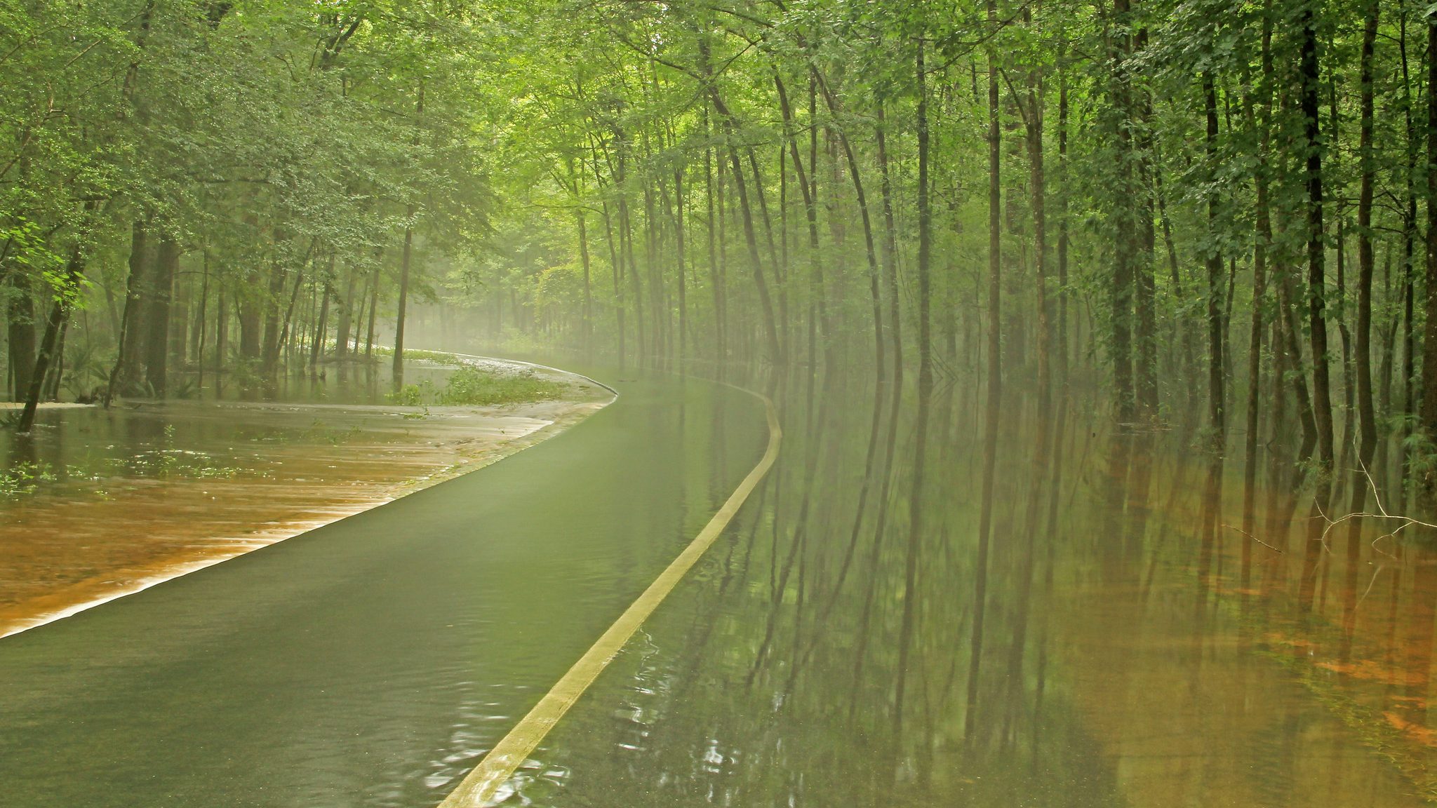
Global mean sea level (GMSL) has risen about 8-9 inches since 1880 with about 3 inches of that occurring in the last 19 years. As global temperatures continue to increase, causing the additional melting of land ice, the GMSL is projected to continue rising. Local effects such as sinking land and changing ocean currents make the Southeast particularly vulnerable and likely to experience sea level rise at higher rates that the global average. Perigean tides, or “king tides,” generally occur twice a year, in the spring, and cause high tide flooding throughout coastal areas. These recurring flood events lead to frequent road closures, excessive water in storm water management systems, and deterioration of roads and railways. These threats, along with an increased flooding risk have prompted coastal cities to initiate adaptation efforts.
Note that each figure on the NCA4 website has an eyeball icon associated with it that gives users access to detailed metadata. This can be used to recreate the figures and accurately portray the findings. Some figures have a gear icon that directs the reader to the Climate Resilience Toolkit, a powerful resource with hundreds of case studies and a Climate Explorer tool that allows users to explore dozens of climate parameters at the zip code level. In addition, we have created pdf versions of each figure for ease of saving the image with associated legend.
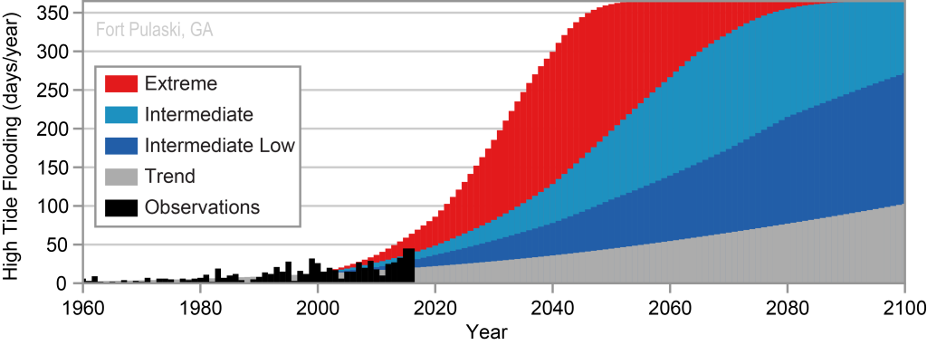 The curves in this figure represent a range of daily Mean Higher High Water (MHHW) levels for the 1960s and 2010s at Sewells Point in Norfolk, VA. Local sea level rise has shifted the curve closer to the point where high tide flooding begins (based on the National Weather Service warning thresholds). This graph indicates why high tide flooding occurs more often now than in the past, with an overall increase of 6 flood days per year.
(Link to Figure 19.8 | Downloadable PDF)
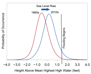 Figure 19.8:
Range of Daily Highest Water Levels in Norfolk, Virginia
The curves in this figure represent a range of daily Mean Higher High Water (MHHW) levels for the 1960s and 2010s at Sewells Point in Norfolk, VA. Local sea level rise has shifted the curve closer to the point where high tide flooding begins (based on the National Weather Service warning thresholds). This graph indicates why high tide flooding occurs more often now than in the past, with an overall increase of 6 flood days per year.
(Link to Figure 19.8 | Downloadable PDF)
CASE STUDY:
Charleston, South Carolina, Begins Planning and Reinvesting for Sea Level Rise
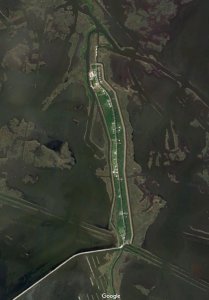
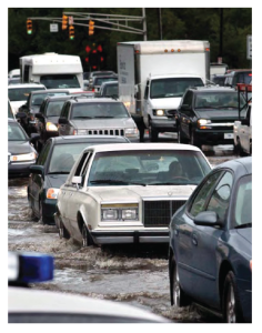 The U.S. 17 Septima Clark pathway (crosstown), located in the historic coastal city of Charleston, South Carolina is often exposed to flooding events which cause vehicles to stall. These flooding events are expected to increase in prevalence, threatening this coastal city with a projected 180 high tide flood events per year by 2045. The City of Charleston estimates that each flood event that affects the crosstown costs $12.4 million (in 2009 dollars). Thus, the city has developed a Sea Level Rise Strategy that plans for a 50-year outlook (Figure 19.10), and that reinvests in infrastructure, develops a response plan, and increases readiness. In response to this effort, construction for the Market Street drainage tunnel has already begun, which redirects storm water to the local Ashley River to prevent future flooding. Link to Case Study.
Figure 19.10: Projected Sea Level Rise for Charleston, South Carolina:
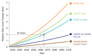 The City of Charleston Sea Level Rise Strategy provides a 50-year outlook, based on the 2015 federal sea level change projections (colored curves), and calls for using a range of 1.5–2.5 feet of sea level rise (dashed box). This range of scenarios is important for city planning, as the 1.5-foot increase will be used for short-term, less vulnerable investments, such as a parking lot, while the 2.5-foot increase will be used for critical, longer-term investments, such as emergency routes.
(Link to Fig. 19.10 | Downloadable PDF)
Figure 19.12: October 2015 Extreme Rainfall Event:
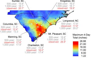 This map shows total rainfall amounts from the South Carolina flood event in October 2015. The red colors indicate areas that received excessive rainfall totals and broke all-time records. Some of these rainfall totals exceeded the 500-year and 1,000-year return period amounts which are only expected to have a 0.2% or 0.1% chance of occurring in a given year. Extreme precipitation events will likely increase in frequency in the Southeast, posing additional flooding risk.
(Link to Fig. 19.12 | Downloadable PDF)
CASE STUDY:
A Lesson Learned for Community Resettlement:
Isle de Jean Charles Band of Biloxi-Chitimacha-Choctaw Tribe
 Isle de Jean Charles is a narrow island located in the bayous of South Terrebonne Parish, Louisiana, that has lost 98% of its landmass since 1955. With only 320 acres of the island remaining, the Isle de Jean Charles Band of Biloxi-Chitimacha-Choctaw, the Tribal community which resides there, faces a tough decision: to remain in their homelands or to relocate. In addition to the loss of land due to sea level rise, unsustainable development, and coastal flooding, the Tribe has watched as their livelihood and culture slowly disappear. After 20 years of persistence, the U.S. Department of Housing and Urban Development (HUD) awarded the state of Louisiana with $48 million to implement a community-driven, culturally appropriate, sustainable development-based resettlement plan, expected to be implemented by 2022. This historic opportunity will allow the tribe to reunite and rebuild their community. Link to Case Study.
The 2017 Hurricane Season
Figure 19.14: Warm Waters Contribute to the Formation of Hurricane Irma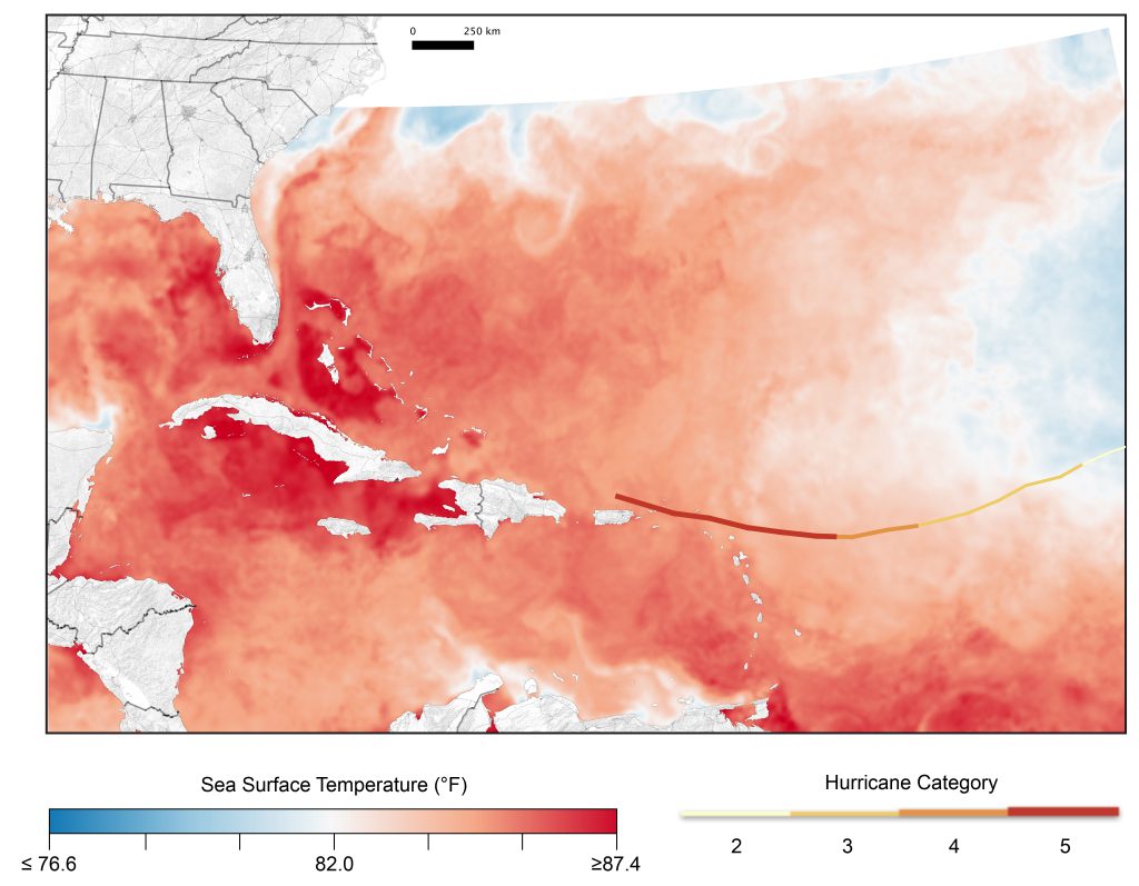 (Link to Figure 19.14 | Downloadable PDF)
Evidence, Likelihood, and Confidence for Key Message 2
Evidence of impacts to the Southeast are supported by the geography of the region, which contains a large number of cities located at or below sea level at an increased risk of flooding. Additionally, the natural climate of the Southeast provides a conducive atmosphere for health issues including the spread of disease. Uncertainties include population projections, shifts in immigration or migration rates, and shifting demographics. See more.
SE CASC funding and researchers have implemented projects relevant to this Key Message:
![]() A Handbook for Resource Managers to Understand and Utilize Sea-Level Rise and Coastal Wetland Models.
A Handbook for Resource Managers to Understand and Utilize Sea-Level Rise and Coastal Wetland Models.
Project details.
![]() Understanding Conservation Management Decisions in the Face of Sea-Level Rise Along the U.S. Atlantic Coast.
Understanding Conservation Management Decisions in the Face of Sea-Level Rise Along the U.S. Atlantic Coast.
Project details.
![]() The Vulnerability of Sea Turtle Nesting Beaches to Climate Change in the Southeastern United States.
The Vulnerability of Sea Turtle Nesting Beaches to Climate Change in the Southeastern United States.
Project details.
![]() Communicating Future Sea-Level Rise Scenarios for Gulf Coast National Wildlife Refuge and National Park Lands.
Communicating Future Sea-Level Rise Scenarios for Gulf Coast National Wildlife Refuge and National Park Lands.
Project details.
![]() Identifying Conservation Objectives for the Gulf Coast Habitats of the Black Skimmer and Gull-billed Tern.
Identifying Conservation Objectives for the Gulf Coast Habitats of the Black Skimmer and Gull-billed Tern.
Project details.
Project details.
View a Guide to Understanding the Southeast Chapter of the NCA4
- Categories: